As Typhoon Julian continues to strengthen and approach the northern Philippines, it is crucial to stay updated on its latest movements and potential impacts. This page provides real-time updates, including storm intensity, movement, wind signals, and forecasts. The information here is sourced from the Philippine Atmospheric, Geophysical, and Astronomical Services Administration (PAGASA) and will be regularly updated as new bulletins are released.
Typhoon Julian is expected to bring heavy rainfall, strong winds, and possible storm surges to various areas, particularly in Batanes, Babuyan Islands, and northern Luzon. Coastal communities and those in elevated areas are advised to take precautionary measures and monitor government warnings.
Below, you’ll find detailed summaries of PAGASA’s bulletins in reverse order, providing you with the latest forecast, wind signals, and advisories for your region. Stay safe, and be prepared as Typhoon Julian makes its way through the Philippine area of responsibility (PAR).
Bulletin 22 – 5:00 AM, 1 October 2024
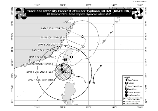
- Location: 205 km West of Itbayat, Batanes (20.6°N, 119.9°E)
- Intensity: Maximum sustained winds of 185 km/h, gustiness up to 230 km/h
- Movement: West northwestward slowly
- Forecast: Super Typhoon Julian is expected to make landfall along the southwestern coast of Taiwan tomorrow (2 October) morning or afternoon. It will then cross the rugged terrain of Taiwan and emerge over the sea east of Taiwan on Thursday (3 October).
Tropical Cyclone Wind Signals (TCWS):
- Signal No. 2: Batanes, Babuyan Islands, northern Ilocos Norte, and northwestern mainland Cagayan
- Signal No. 1: Rest of Ilocos Norte, Ilocos Sur, La Union, Pangasinan, Apayao, Kalinga, Abra, Mountain Province, Ifugao, Benguet, Cagayan, Isabela, Quirino, Nueva Vizcaya, northern Aurora, and northern Nueva Ecija
Coastal Inundation: Moderate to high risk of life-threatening storm surges in low-lying coastal areas of Batanes and Babuyan Islands.
Sea Conditions: Seas are dangerous with waves up to 7.0 m over Batanes and 6.0 m over Babuyan Islands. Sea travel is risky for all vessels.
Bulletin 21 – 11:00 PM, 30 September 2024
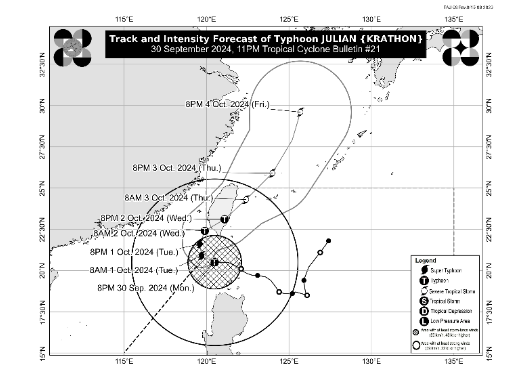
- Location: 155 km West Southwest of Itbayat, Batanes (20.5°N, 120.4°E)
- Intensity: Maximum sustained winds of 175 km/h, gustiness up to 215 km/h
- Movement: Westward at 15 km/h
- Forecast: Typhoon Julian will turn northwestward and begin recurving towards the southwestern coast of Taiwan, with potential landfall on 2 October.
Tropical Cyclone Wind Signals (TCWS):
- Signal No. 3: Batanes
- Signal No. 2: Babuyan Islands, Ilocos Norte, northern Apayao, and northwestern mainland Cagayan
- Signal No. 1: Ilocos Sur, La Union, Pangasinan, Apayao, Kalinga, Abra, Mountain Province, Ifugao, Benguet, Cagayan, Isabela, Quirino, Nueva Vizcaya, northern Aurora, and northern Nueva Ecija
Coastal Inundation: Moderate to high risk of life-threatening storm surges in low-lying areas of Batanes and Babuyan Islands.
Sea Conditions: Seas remain dangerous with waves up to 9.0 m over Batanes and 8.0 m over Babuyan Islands. Sea travel is highly discouraged for all vessels.
Bulletin 20 – 5:00 PM, 30 September 2024
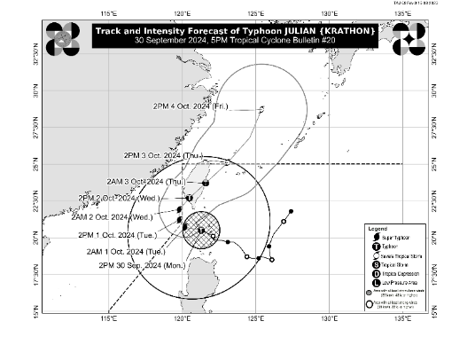
- Location: 95 km West Southwest of Itbayat, Batanes (20.5°N, 121.0°E)
- Intensity: Maximum sustained winds of 175 km/h, gustiness up to 215 km/h
- Movement: West northwestward at 15 km/h
- Forecast: Typhoon Julian is moving away from Batanes towards the northwestern boundary of the Philippine Area of Responsibility (PAR).
Tropical Cyclone Wind Signals (TCWS):
- Signal No. 4: Batanes
- Signal No. 3: Northern and western Babuyan Islands
- Signal No. 2: Mainland Cagayan, Apayao, Abra, Kalinga, Ilocos Norte, northern and central Ilocos Sur
- Signal No. 1: Rest of Ilocos Sur, La Union, Pangasinan, Ifugao, Mountain Province, Benguet, Isabela, Nueva Vizcaya, Quirino, northern Aurora, and northern Nueva Ecija
Coastal Inundation: Moderate to high risk of storm surges in low-lying coastal areas of Batanes and Babuyan Islands.
Sea Conditions: Waves up to 14.0 m in Batanes and 10.0 m in Babuyan Islands. Sea travel is risky for all types of vessels.
Bulletin 19 – 2:00 PM, 30 September 2024
- Location: Over the coastal waters of Sabtang Island, Batanes (20.5°N, 121.4°E)
- Intensity: Maximum sustained winds of 175 km/h, gustiness up to 240 km/h
- Movement: West northwestward at 15 km/h
- Forecast: Typhoon Julian is expected to continue intensifying, possibly reaching super typhoon status as it moves over the Bashi Channel towards Taiwan.
Tropical Cyclone Wind Signals (TCWS):
- Signal No. 4: Batanes
- Signal No. 3: Babuyan Islands
- Signal No. 2: Mainland Cagayan, Apayao, Abra, Kalinga, Ilocos Norte, and northern/central Ilocos Sur
- Signal No. 1: Rest of Ilocos Sur, La Union, Pangasinan, Ifugao, Mountain Province, Benguet, Isabela, Nueva Vizcaya, Quirino, northern/central Aurora, and northern/eastern Nueva Ecija
Coastal Inundation: Moderate to high risk of life-threatening storm surges over Batanes, Cagayan, and Ilocos Norte in the next 48 hours.
Sea Conditions: Seas are extremely dangerous with waves up to 14.0 m over Batanes and 10.0 m over Babuyan Islands.
Bulletin 18 – 11:00 AM, 30 September 2024
- Location: Over the coastal waters of Sabtang Island, Batanes (20.2°N, 121.8°E)
- Intensity: Maximum sustained winds of 175 km/h, gustiness up to 240 km/h
- Movement: North northwestward at 10 km/h
- Forecast: Typhoon Julian is expected to pass 135 km west of Basco, Batanes, this evening. It may reach super typhoon status with winds of 185 km/h. Potential landfall is possible in Batanes or Babuyan Islands.
Tropical Cyclone Wind Signals (TCWS):
- Signal No. 4: Batanes and northern Babuyan Islands (Babuyan Island, Calayan Island)
- Signal No. 3: Rest of Babuyan Islands and northeastern mainland Cagayan (Santa Ana)
- Signal No. 2: Mainland Cagayan, Apayao, Abra, Kalinga, Ilocos Norte, and northern and central Ilocos Sur
- Signal No. 1: Rest of Ilocos Sur, La Union, Pangasinan, Ifugao, Mountain Province, Benguet, Isabela, Nueva Vizcaya, Quirino, Aurora, northern and eastern Nueva Ecija, and Polillo Islands
Coastal Inundation: Moderate to high risk of life-threatening storm surge over Batanes, Cagayan, and Ilocos Norte. Gale warnings in effect, with waves up to 14.0 m over Batanes and 10.0 m over Babuyan Islands.
Sea Conditions: Extremely dangerous for all types of vessels. Mariners should remain in port.
Bulletin 17 – 8:00 AM, 30 September 2024
- Location: Over the coastal waters of Balintang Island, Cagayan (19.9°N, 122.2°E)
- Intensity: Maximum sustained winds of 175 km/h, gustiness up to 215 km/h
- Movement: West northwestward at 10 km/h
- Forecast: Expected to pass close to Basco, Batanes within 12 hours. Julian may reach super typhoon status, with winds of 185 km/h. Potential landfall in Batanes or Babuyan Islands.
Tropical Cyclone Wind Signals (TCWS):
- Signal No. 4: Batanes and northern Babuyan Islands (Babuyan Island, Calayan Island)
- Signal No. 3: Rest of Babuyan Islands and northeastern mainland Cagayan (Santa Ana)
- Signal No. 2: Mainland Cagayan, Apayao, northern Abra, northern Kalinga, Ilocos Norte, northern Ilocos Sur
- Signal No. 1: Rest of Ilocos Sur, La Union, Pangasinan, rest of Abra, Kalinga, Ifugao, Mountain Province, Benguet, Isabela, Nueva Vizcaya, Quirino, Aurora, northern and eastern Nueva Ecija, and Polillo Islands
Coastal Inundation: Moderate to high risk of life-threatening storm surge over Batanes, Cagayan, and Ilocos Norte. Gale warnings in effect, with waves up to 14.0 m over Batanes and 10.0 m over Babuyan Islands.
Sea Conditions: Extremely dangerous for all types of vessels. Mariners should remain in port.
Bulletin 16 – 5:00 AM, 30 September 2024
- Location: Over the coastal waters of Balintang Island, Cagayan (19.9°N, 122.2°E)
- Intensity: Maximum sustained winds of 155 km/h, gustiness up to 190 km/h
- Movement: Westward at 10 km/h
- Forecast: Expected to pass over Sabtang, Batanes, intensifying to 185 km/h over the next 24 hours.
Tropical Cyclone Wind Signals (TCWS):
- Signal No. 4: Batanes and the northern portion of Babuyan Islands
- Signal No. 3: The rest of Babuyan Islands and northeastern mainland Cagayan (Santa Ana)
- Signal No. 2: Mainland Cagayan, Apayao, Ilocos Norte
- Signal No. 1: Ilocos Sur, La Union, Pangasinan, Abra, Kalinga, Ifugao, Mountain Province, Benguet, Isabela, Nueva Vizcaya, Quirino, Aurora, and northern and eastern Nueva Ecija
Coastal Inundation: Moderate to high risk of life-threatening storm surges over Batanes, Babuyan Islands, and northern Cagayan.
Bulletin 15 – 2:00 AM, 30 September 2024
- Location: 95 km Southeast of Basco, Batanes (19.8°N, 122.6°E)
- Intensity: Maximum sustained winds of 155 km/h, gustiness up to 190 km/h
- Movement: West northwestward at 15 km/h
- Forecast: Typhoon expected to intensify further, potentially reaching 185 km/h within 36 hours.
Tropical Cyclone Wind Signals (TCWS):
- Signal No. 4: Batanes and northern Babuyan Islands
- Signal No. 3: The rest of Babuyan Islands, northeastern mainland Cagayan (Santa Ana)
- Signal No. 2: Mainland Cagayan, Apayao, Ilocos Norte
- Signal No. 1: Ilocos Sur, La Union, Pangasinan, Abra, Kalinga, Ifugao, Mountain Province, Benguet, Isabela, Nueva Vizcaya, Quirino, and northern and eastern Nueva Ecija
Coastal Inundation: Storm surge warnings remain in effect with a high risk in low-lying coastal areas.
Bulletin 14 – 11:00 PM, 29 September 2024
- Location: 125 km Southeast of Basco, Batanes (19.7°N, 122.9°E)
- Intensity: Maximum sustained winds of 150 km/h, gustiness up to 185 km/h
- Movement: Westward at 15 km/h
- Forecast: Typhoon to cross Batanes, intensifying to 165 km/h within 24 hours.
Tropical Cyclone Wind Signals (TCWS):
- Signal No. 4: Batanes and northeastern Babuyan Islands
- Signal No. 3: The rest of Babuyan Islands
- Signal No. 2: Mainland Cagayan, Apayao, Ilocos Norte
- Signal No. 1: Ilocos Sur, La Union, Abra, Kalinga, Ifugao, Mountain Province, Benguet, Isabela, Nueva Vizcaya, Quirino, and northern and central Aurora
Coastal Inundation: Life-threatening storm surge expected in Batanes, Babuyan Islands, and northern mainland Cagayan.
Bulletin 13 – 8:00 PM, 29 September 2024
- Location: 150 km East Southeast of Basco, Batanes (19.7°N, 123.2°E)
- Intensity: Maximum sustained winds of 140 km/h, gustiness up to 170 km/h
- Movement: Northwestward at 15 km/h
- Forecast: Expected to reach 155 km/h as it nears Batanes, with landfall anticipated.
Tropical Cyclone Wind Signals (TCWS):
- Signal No. 4: Batanes
- Signal No. 3: Babuyan Islands
- Signal No. 2: Mainland Cagayan, Apayao, Ilocos Norte
- Signal No. 1: Ilocos Sur, La Union, Abra, Kalinga, Ifugao, Mountain Province, Benguet, Isabela, Nueva Vizcaya, Quirino, northern and central Aurora
Coastal Inundation: Storm surge warnings issued for Batanes, Babuyan Islands, and northern Cagayan.
Bulletin 12 – 5:00 PM, 29 September 2024
- Location: 235 km East of Calayan, Cagayan (19.5°N, 123.7°E)
- Intensity: Maximum sustained winds of 120 km/h, gustiness up to 150 km/h
- Movement: Northwestward at 15 km/h
- Forecast: Typhoon expected to pass over Basco, Batanes, intensifying to 155 km/h within 24 hours.
Tropical Cyclone Wind Signals (TCWS):
- Signal No. 3: Batanes and northeastern Babuyan Islands
- Signal No. 2: Mainland Cagayan, Babuyan Islands, Apayao, Ilocos Norte
- Signal No. 1: Ilocos Sur, La Union, Abra, Kalinga, Ifugao, Mountain Province, Benguet, Isabela, Nueva Vizcaya, Quirino, northern and central Aurora
Bulletin 11 – 2:00 PM, 29 September 2024
- Location: 275 km East of Calayan, Cagayan (19.1°N, 124.1°E)
- Intensity: Maximum sustained winds of 120 km/h, gustiness up to 135 km/h
- Movement: North northwestward at 15 km/h
- Forecast: Strengthening typhoon approaching Batanes with possible winds up to 165 km/h.
Tropical Cyclone Wind Signals (TCWS):
- Signal No. 3: Northeastern Babuyan Islands
- Signal No. 2: Batanes, mainland Cagayan, Babuyan Islands, Apayao, northern and central Ilocos Norte
- Signal No. 1: Ilocos Sur, La Union, Abra, Kalinga, Ifugao, Mountain Province, Benguet, Isabela, Nueva Vizcaya, Quirino, and northern and central Aurora
Bulletin 10 – 11:00 AM, 29 September 2024
- Location: 290 km East Northeast of Aparri, Cagayan (18.6°N, 124.3°E)
- Intensity: Maximum sustained winds of 110 km/h, gustiness up to 135 km/h
- Movement: West northwestward slowly
- Forecast: Typhoon nearing Basco, Batanes with winds potentially reaching 130 km/h within 24 hours.
Tropical Cyclone Wind Signals (TCWS):
- Signal No. 3: Northeastern Babuyan Islands
- Signal No. 2: Batanes, mainland Cagayan, Babuyan Islands, Apayao, northern Ilocos Norte
- Signal No. 1: Ilocos Sur, La Union, Abra, Kalinga, Ifugao, Mountain Province, northern Aurora
Bulletin 9 – 5:00 AM, 29 September 2024
- Location: 305 km East of Aparri, Cagayan (18.6°N, 124.5°E)
- Intensity: Maximum sustained winds of 95 km/h, gustiness up to 115 km/h
- Movement: West northwestward at 10 km/h
- Forecast: Expected to intensify into a typhoon as it approaches Basco, Batanes.
Tropical Cyclone Wind Signals (TCWS):
- Signal No. 2: Northeastern mainland Cagayan, eastern Babuyan Islands
- Signal No. 1: Batanes, Cagayan, Isabela, Apayao, Abra, Kalinga, Ifugao, Mountain Province, Ilocos Norte, northern Aurora
- Location: 205 km West of Itbayat, Batanes (20.6°N, 119.9°E)
- Intensity: Maximum sustained winds of 185 km/h, gustiness up to 230 km/h
- Movement: West northwestward slowly
- Forecast: Super Typhoon Julian is expected to make landfall along the southwestern coast of Taiwan tomorrow (2 October) morning or afternoon. It will then cross the rugged terrain of Taiwan and emerge over the sea east of Taiwan on Thursday (3 October).
Tropical Cyclone Wind Signals (TCWS):
- Signal No. 2: Batanes, Babuyan Islands, northern Ilocos Norte, and northwestern mainland Cagayan
- Signal No. 1: Rest of Ilocos Norte, Ilocos Sur, La Union, Pangasinan, Apayao, Kalinga, Abra, Mountain Province, Ifugao, Benguet, Cagayan, Isabela, Quirino, Nueva Vizcaya, northern Aurora, and northern Nueva Ecija
Coastal Inundation: Moderate to high risk of life-threatening storm surges in low-lying coastal areas of Batanes and Babuyan Islands.
Sea Conditions: Seas are dangerous with waves up to 7.0 m over Batanes and 6.0 m over Babuyan Islands. Sea travel is risky for all vessels.
- Location: 155 km West Southwest of Itbayat, Batanes (20.5°N, 120.4°E)
- Intensity: Maximum sustained winds of 175 km/h, gustiness up to 215 km/h
- Movement: Westward at 15 km/h
- Forecast: Typhoon Julian will turn northwestward and begin recurving towards the southwestern coast of Taiwan, with potential landfall on 2 October.
Tropical Cyclone Wind Signals (TCWS):
- Signal No. 3: Batanes
- Signal No. 2: Babuyan Islands, Ilocos Norte, northern Apayao, and northwestern mainland Cagayan
- Signal No. 1: Ilocos Sur, La Union, Pangasinan, Apayao, Kalinga, Abra, Mountain Province, Ifugao, Benguet, Cagayan, Isabela, Quirino, Nueva Vizcaya, northern Aurora, and northern Nueva Ecija
Coastal Inundation: Moderate to high risk of life-threatening storm surges in low-lying areas of Batanes and Babuyan Islands.
Sea Conditions: Seas remain dangerous with waves up to 9.0 m over Batanes and 8.0 m over Babuyan Islands. Sea travel is highly discouraged for all vessels.
- Location: 95 km West Southwest of Itbayat, Batanes (20.5°N, 121.0°E)
- Intensity: Maximum sustained winds of 175 km/h, gustiness up to 215 km/h
- Movement: West northwestward at 15 km/h
- Forecast: Typhoon Julian is moving away from Batanes towards the northwestern boundary of the Philippine Area of Responsibility (PAR).
Tropical Cyclone Wind Signals (TCWS):
- Signal No. 4: Batanes
- Signal No. 3: Northern and western Babuyan Islands
- Signal No. 2: Mainland Cagayan, Apayao, Abra, Kalinga, Ilocos Norte, northern and central Ilocos Sur
- Signal No. 1: Rest of Ilocos Sur, La Union, Pangasinan, Ifugao, Mountain Province, Benguet, Isabela, Nueva Vizcaya, Quirino, northern Aurora, and northern Nueva Ecija
Coastal Inundation: Moderate to high risk of storm surges in low-lying coastal areas of Batanes and Babuyan Islands.
Sea Conditions: Waves up to 14.0 m in Batanes and 10.0 m in Babuyan Islands. Sea travel is risky for all types of vessels.
- Location: Over the coastal waters of Sabtang Island, Batanes (20.5°N, 121.4°E)
- Intensity: Maximum sustained winds of 175 km/h, gustiness up to 240 km/h
- Movement: West northwestward at 15 km/h
- Forecast: Typhoon Julian is expected to continue intensifying, possibly reaching super typhoon status as it moves over the Bashi Channel towards Taiwan.
Tropical Cyclone Wind Signals (TCWS):
- Signal No. 4: Batanes
- Signal No. 3: Babuyan Islands
- Signal No. 2: Mainland Cagayan, Apayao, Abra, Kalinga, Ilocos Norte, and northern/central Ilocos Sur
- Signal No. 1: Rest of Ilocos Sur, La Union, Pangasinan, Ifugao, Mountain Province, Benguet, Isabela, Nueva Vizcaya, Quirino, northern/central Aurora, and northern/eastern Nueva Ecija
Coastal Inundation: Moderate to high risk of life-threatening storm surges over Batanes, Cagayan, and Ilocos Norte in the next 48 hours.
Sea Conditions: Seas are extremely dangerous with waves up to 14.0 m over Batanes and 10.0 m over Babuyan Islands.
- Location: Over the coastal waters of Sabtang Island, Batanes (20.2°N, 121.8°E)
- Intensity: Maximum sustained winds of 175 km/h, gustiness up to 240 km/h
- Movement: North northwestward at 10 km/h
- Forecast: Typhoon Julian is expected to pass 135 km west of Basco, Batanes, this evening. It may reach super typhoon status with winds of 185 km/h. Potential landfall is possible in Batanes or Babuyan Islands.
Tropical Cyclone Wind Signals (TCWS):
- Signal No. 4: Batanes and northern Babuyan Islands (Babuyan Island, Calayan Island)
- Signal No. 3: Rest of Babuyan Islands and northeastern mainland Cagayan (Santa Ana)
- Signal No. 2: Mainland Cagayan, Apayao, Abra, Kalinga, Ilocos Norte, and northern and central Ilocos Sur
- Signal No. 1: Rest of Ilocos Sur, La Union, Pangasinan, Ifugao, Mountain Province, Benguet, Isabela, Nueva Vizcaya, Quirino, Aurora, northern and eastern Nueva Ecija, and Polillo Islands
Coastal Inundation: Moderate to high risk of life-threatening storm surge over Batanes, Cagayan, and Ilocos Norte. Gale warnings in effect, with waves up to 14.0 m over Batanes and 10.0 m over Babuyan Islands.
Sea Conditions: Extremely dangerous for all types of vessels. Mariners should remain in port.
- Location: Over the coastal waters of Balintang Island, Cagayan (19.9°N, 122.2°E)
- Intensity: Maximum sustained winds of 175 km/h, gustiness up to 215 km/h
- Movement: West northwestward at 10 km/h
- Forecast: Expected to pass close to Basco, Batanes within 12 hours. Julian may reach super typhoon status, with winds of 185 km/h. Potential landfall in Batanes or Babuyan Islands.
Tropical Cyclone Wind Signals (TCWS):
- Signal No. 4: Batanes and northern Babuyan Islands (Babuyan Island, Calayan Island)
- Signal No. 3: Rest of Babuyan Islands and northeastern mainland Cagayan (Santa Ana)
- Signal No. 2: Mainland Cagayan, Apayao, northern Abra, northern Kalinga, Ilocos Norte, northern Ilocos Sur
- Signal No. 1: Rest of Ilocos Sur, La Union, Pangasinan, rest of Abra, Kalinga, Ifugao, Mountain Province, Benguet, Isabela, Nueva Vizcaya, Quirino, Aurora, northern and eastern Nueva Ecija, and Polillo Islands
Coastal Inundation: Moderate to high risk of life-threatening storm surge over Batanes, Cagayan, and Ilocos Norte. Gale warnings in effect, with waves up to 14.0 m over Batanes and 10.0 m over Babuyan Islands.
Sea Conditions: Extremely dangerous for all types of vessels. Mariners should remain in port.
- Location: Over the coastal waters of Balintang Island, Cagayan (19.9°N, 122.2°E)
- Intensity: Maximum sustained winds of 155 km/h, gustiness up to 190 km/h
- Movement: Westward at 10 km/h
- Forecast: Expected to pass over Sabtang, Batanes, intensifying to 185 km/h over the next 24 hours.
Tropical Cyclone Wind Signals (TCWS):
- Signal No. 4: Batanes and the northern portion of Babuyan Islands
- Signal No. 3: The rest of Babuyan Islands and northeastern mainland Cagayan (Santa Ana)
- Signal No. 2: Mainland Cagayan, Apayao, Ilocos Norte
- Signal No. 1: Ilocos Sur, La Union, Pangasinan, Abra, Kalinga, Ifugao, Mountain Province, Benguet, Isabela, Nueva Vizcaya, Quirino, Aurora, and northern and eastern Nueva Ecija
Coastal Inundation: Moderate to high risk of life-threatening storm surges over Batanes, Babuyan Islands, and northern Cagayan.
- Location: 95 km Southeast of Basco, Batanes (19.8°N, 122.6°E)
- Intensity: Maximum sustained winds of 155 km/h, gustiness up to 190 km/h
- Movement: West northwestward at 15 km/h
- Forecast: Typhoon expected to intensify further, potentially reaching 185 km/h within 36 hours.
Tropical Cyclone Wind Signals (TCWS):
- Signal No. 4: Batanes and northern Babuyan Islands
- Signal No. 3: The rest of Babuyan Islands, northeastern mainland Cagayan (Santa Ana)
- Signal No. 2: Mainland Cagayan, Apayao, Ilocos Norte
- Signal No. 1: Ilocos Sur, La Union, Pangasinan, Abra, Kalinga, Ifugao, Mountain Province, Benguet, Isabela, Nueva Vizcaya, Quirino, and northern and eastern Nueva Ecija
Coastal Inundation: Storm surge warnings remain in effect with a high risk in low-lying coastal areas.
- Location: 125 km Southeast of Basco, Batanes (19.7°N, 122.9°E)
- Intensity: Maximum sustained winds of 150 km/h, gustiness up to 185 km/h
- Movement: Westward at 15 km/h
- Forecast: Typhoon to cross Batanes, intensifying to 165 km/h within 24 hours.
Tropical Cyclone Wind Signals (TCWS):
- Signal No. 4: Batanes and northeastern Babuyan Islands
- Signal No. 3: The rest of Babuyan Islands
- Signal No. 2: Mainland Cagayan, Apayao, Ilocos Norte
- Signal No. 1: Ilocos Sur, La Union, Abra, Kalinga, Ifugao, Mountain Province, Benguet, Isabela, Nueva Vizcaya, Quirino, and northern and central Aurora
Coastal Inundation: Life-threatening storm surge expected in Batanes, Babuyan Islands, and northern mainland Cagayan.
- Location: 150 km East Southeast of Basco, Batanes (19.7°N, 123.2°E)
- Intensity: Maximum sustained winds of 140 km/h, gustiness up to 170 km/h
- Movement: Northwestward at 15 km/h
- Forecast: Expected to reach 155 km/h as it nears Batanes, with landfall anticipated.
Tropical Cyclone Wind Signals (TCWS):
- Signal No. 4: Batanes
- Signal No. 3: Babuyan Islands
- Signal No. 2: Mainland Cagayan, Apayao, Ilocos Norte
- Signal No. 1: Ilocos Sur, La Union, Abra, Kalinga, Ifugao, Mountain Province, Benguet, Isabela, Nueva Vizcaya, Quirino, northern and central Aurora
Coastal Inundation: Storm surge warnings issued for Batanes, Babuyan Islands, and northern Cagayan.
- Location: 235 km East of Calayan, Cagayan (19.5°N, 123.7°E)
- Intensity: Maximum sustained winds of 120 km/h, gustiness up to 150 km/h
- Movement: Northwestward at 15 km/h
- Forecast: Typhoon expected to pass over Basco, Batanes, intensifying to 155 km/h within 24 hours.
Tropical Cyclone Wind Signals (TCWS):
- Signal No. 3: Batanes and northeastern Babuyan Islands
- Signal No. 2: Mainland Cagayan, Babuyan Islands, Apayao, Ilocos Norte
- Signal No. 1: Ilocos Sur, La Union, Abra, Kalinga, Ifugao, Mountain Province, Benguet, Isabela, Nueva Vizcaya, Quirino, northern and central Aurora
- Location: 275 km East of Calayan, Cagayan (19.1°N, 124.1°E)
- Intensity: Maximum sustained winds of 120 km/h, gustiness up to 135 km/h
- Movement: North northwestward at 15 km/h
- Forecast: Strengthening typhoon approaching Batanes with possible winds up to 165 km/h.
Tropical Cyclone Wind Signals (TCWS):
- Signal No. 3: Northeastern Babuyan Islands
- Signal No. 2: Batanes, mainland Cagayan, Babuyan Islands, Apayao, northern and central Ilocos Norte
- Signal No. 1: Ilocos Sur, La Union, Abra, Kalinga, Ifugao, Mountain Province, Benguet, Isabela, Nueva Vizcaya, Quirino, and northern and central Aurora
- Location: 290 km East Northeast of Aparri, Cagayan (18.6°N, 124.3°E)
- Intensity: Maximum sustained winds of 110 km/h, gustiness up to 135 km/h
- Movement: West northwestward slowly
- Forecast: Typhoon nearing Basco, Batanes with winds potentially reaching 130 km/h within 24 hours.
Tropical Cyclone Wind Signals (TCWS):
- Signal No. 3: Northeastern Babuyan Islands
- Signal No. 2: Batanes, mainland Cagayan, Babuyan Islands, Apayao, northern Ilocos Norte
- Signal No. 1: Ilocos Sur, La Union, Abra, Kalinga, Ifugao, Mountain Province, northern Aurora
- Location: 305 km East of Aparri, Cagayan (18.6°N, 124.5°E)
- Intensity: Maximum sustained winds of 95 km/h, gustiness up to 115 km/h
- Movement: West northwestward at 10 km/h
- Forecast: Expected to intensify into a typhoon as it approaches Basco, Batanes.
Tropical Cyclone Wind Signals (TCWS):
- Signal No. 2: Northeastern mainland Cagayan, eastern Babuyan Islands
- Signal No. 1: Batanes, Cagayan, Isabela, Apayao, Abra, Kalinga, Ifugao, Mountain Province, Ilocos Norte, northern Aurora